pdok_geocode() turns a name — an address, a postcode, a
street, a town, a municipality, a province — into spatial data, using
the PDOK Locatieserver. The result is
an sf object, so it plugs straight into the rest of
pdokr: most usefully, a geocoded boundary can be handed to
the filter_by argument of pdok_read().
library(pdokr)
library(tmap)
library(dplyr)
#>
#> Attaching package: 'dplyr'
#> The following objects are masked from 'package:stats':
#>
#>     filter, lag
#> The following objects are masked from 'package:base':
#>
#>     intersect, setdiff, setequal, union
A name to a point
In its simplest form you pass a query and get back the single best match.
home <- pdok_geocode("Domplein 1, Utrecht")
home |> select(weergavenaam, type, score)
#> Simple feature collection with 1 feature and 3 fields
#> Geometry type: MULTILINESTRING
#> Dimension:     XY
#> Bounding box:  xmin: 5.12111 ymin: 52.09004 xmax: 5.1224 ymax: 52.09118
#> Geodetic CRS:  WGS 84
#> # A tibble: 1 × 4
#>   weergavenaam      type  score                                         geometry
#>   <chr>             <chr> <dbl>                            <MULTILINESTRING [°]>
#> 1 Domplein, Utrecht weg    15.8 ((5.12193 52.09004, 5.12149 52.09093), (5.12149…
It is an ordinary sf object with a point geometry, ready
to map.
tmap_mode("view")
#> ℹ tmap modes "plot" - "view"
#> ℹ toggle with `tmap::ttm()`

tm_basemap(pdok_basemap("grijs")) +
  tm_shape(home) +
  tm_dots(fill = "#E8631C", size = 1) +
  tm_credits("Kaartgegevens © Kadaster")
Search levels: the type argument
The Locatieserver does not only know addresses. Every result has a
type, and the geometry you get back depends on it — a point
for pinpoint locations, a line for a road, a polygon for an area.
type |
Geometry | What it is |
|---|---|---|
adres |
point | a specific address |
postcode |
point | the center of a postcode |
hectometerpaal |
point | a motorway distance marker |
appartementsrecht |
point | an apartment right |
weg |
line | a (named) road |
buurt, wijk
|
polygon | a neighborhood or district |
woonplaats |
polygon | a town or city |
gemeente |
polygon | a municipality |
provincie |
polygon | a province |
perceel |
polygon | a cadastral parcel |
By default pdok_geocode() returns the best match of
any type, ranked by the service’s relevance score.
That is convenient, but a single name often exists at several levels —
“Utrecht” is a municipality, a province, and a town:
pdok_geocode("Utrecht", limit = 5) |>
  select(weergavenaam, type, score)
#> Simple feature collection with 5 features and 3 fields
#> Geometry type: MULTIPOLYGON
#> Dimension:     XY
#> Bounding box:  xmin: 4.9701 ymin: 52.02628 xmax: 5.19515 ymax: 52.14205
#> Geodetic CRS:  WGS 84
#> # A tibble: 5 × 4
#>   weergavenaam                  type       score                        geometry
#>   <chr>                         <chr>      <dbl>              <MULTIPOLYGON [°]>
#> 1 Gemeente Utrecht              gemeente   10.2  (((5.01801 52.06222, 5.01707 5…
#> 2 Utrecht, Utrecht, Utrecht     woonplaats  9.24 (((5.01514 52.11395, 5.01553 5…
#> 3 Haarzuilens, Utrecht, Utrecht woonplaats  9.02 (((4.97775 52.13057, 4.97394 5…
#> 4 Vleuten, Utrecht, Utrecht     woonplaats  9.02 (((4.98085 52.10015, 4.98933 5…
#> 5 De Meern, Utrecht, Utrecht    woonplaats  8.95 (((5.0429 52.08946, 5.04283 52…
Pass type to pin down exactly which level you mean. The
same query then returns very different geometry:
point <- pdok_geocode("Domplein 1, Utrecht")          # adres  -> point
road  <- pdok_geocode("Oudegracht, Utrecht", type = "weg")   # weg    -> line
area  <- pdok_geocode("Binnenstad, Utrecht", type = "wijk")  # wijk   -> polygon

sf::st_geometry_type(point)
#> [1] MULTILINESTRING
#> 18 Levels: GEOMETRY POINT LINESTRING POLYGON MULTIPOINT ... TRIANGLE
sf::st_geometry_type(road)
#> [1] MULTILINESTRING
#> 18 Levels: GEOMETRY POINT LINESTRING POLYGON MULTIPOINT ... TRIANGLE
sf::st_geometry_type(area)
#> [1] MULTIPOLYGON
#> 18 Levels: GEOMETRY POINT LINESTRING POLYGON MULTIPOINT ... TRIANGLE
Seen together, the three levels nest neatly — the address sits on the road, which lies inside the district.
tm_shape(area) +
  tm_polygons(fill = "#F7F3EC", col = "grey50") +
  tm_shape(road) +
  tm_lines(col = "#1f78b4", lwd = 2) +
  tm_shape(point) +
  tm_dots(fill = "#E8631C", size = 0.6) +
  tm_title("Three search levels: district, road, address")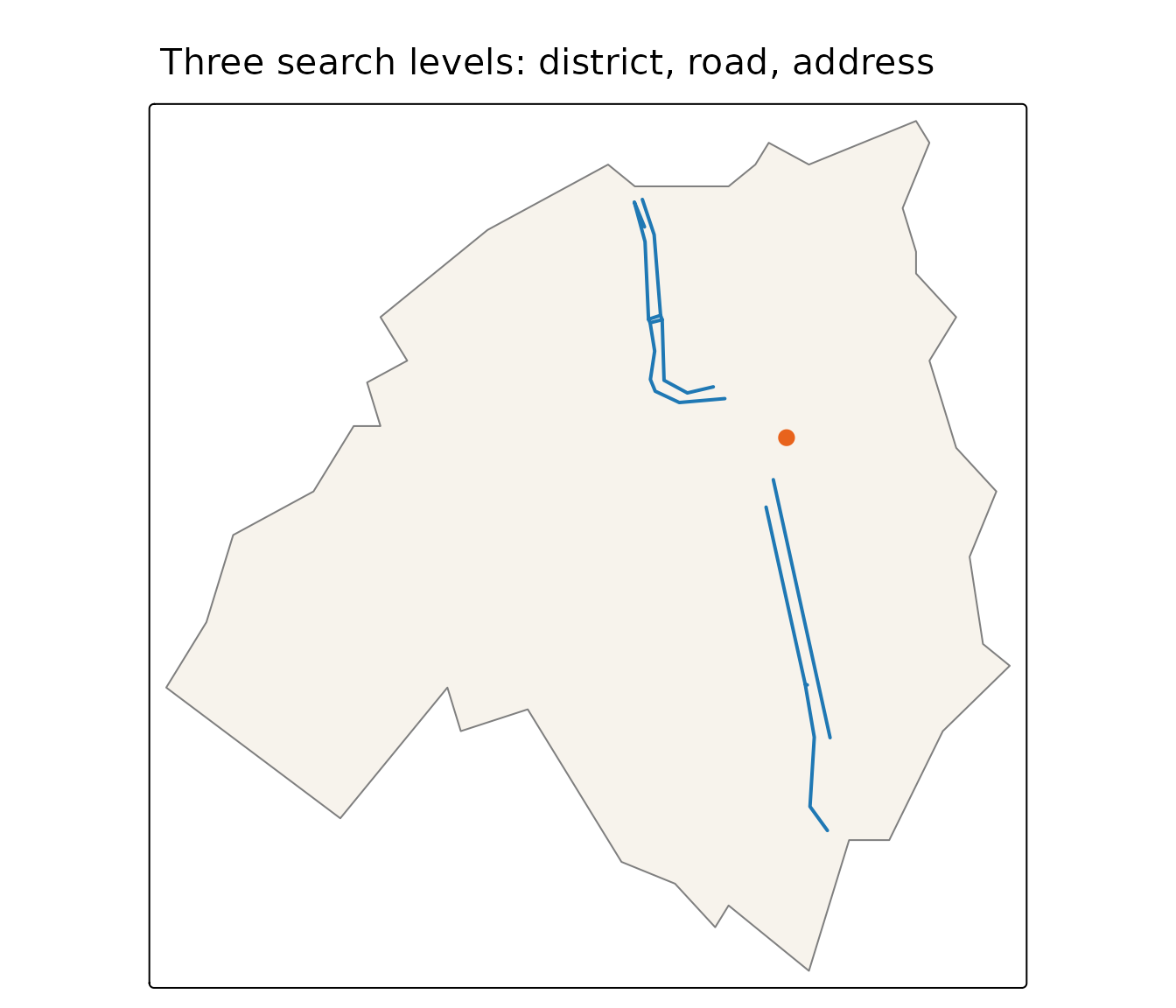
Combine with pdok_filter_by()
This is where geocoding earns its place in a workflow. Many tasks
start with “the data inside this area” — and
pdok_geocode() gives you that area as a boundary without
having to find and load an administrative layer first. A geocoded
gemeente, wijk or provincie
polygon drops straight into filter_by.
boundary <- pdok_geocode("De Bilt", type = "gemeente")

# read the neighborhoods that meet the boundary, then keep those whose center
# lies inside it. A geocoded boundary is generalized, so it clips edge
# neighborhoods unevenly; `predicate = "within"` alone would drop some, while
# `"intersects"` pulls in slivers of neighboring municipalities.
buurten <- pdok_read(
  "cbs/gebiedsindelingen", "buurt_gegeneraliseerd", datetime = 2025,
  filter_by = boundary, predicate = "intersects"
)
centers <- suppressWarnings(sf::st_centroid(buurten))
buurten <- filter(buurten, lengths(sf::st_within(centers, boundary)) > 0)
nrow(buurten)
#> [1] 24
The geocoded boundary did the filtering; the result is every neighborhood inside the municipality of De Bilt. On an interactive map you can see where that is and hover for the neighborhood names:
tmap_mode("view")
#> ℹ tmap modes "plot" - "view"

tm_basemap(pdok_basemap("grijs")) +
  tm_shape(buurten) +
  tm_polygons(
    fill = "statnaam",
    fill.scale = tm_scale_categorical(values = "brewer.set3"),
    fill.legend = tm_legend(show = FALSE),
    col = "white", fill_alpha = 0.6, id = "statnaam"
  ) +
  tm_credits("Kaartgegevens © Kadaster")
The same pattern works for any layer: geocode the area you care about, then read the buildings, parcels or statistics within it.
Geocoding a whole column
pdok_geocode() takes a vector of queries, so
you can geocode a column of addresses in one call. Every result row
carries a query column identifying the input it came from,
which keeps the output aligned with the input — even when a query
returns several candidates, or none.
Free search ranks matches across all levels — the exact
address, but also the street or place it sits on — and returns the
best-ranked one per query. So keep an eye on the type
column: below, two queries resolve to the street (weg)
rather than the house number, which is why their geometry is a line, not
a point.
addresses <- c("Domplein 1, Utrecht", "Coolsingel 40, Rotterdam",
               "Vrijthof 1, Maastricht")

pdok_geocode(addresses)[, c("query", "type", "weergavenaam")]
#> Simple feature collection with 3 features and 3 fields
#> Geometry type: GEOMETRY
#> Dimension:     XY
#> Bounding box:  xmin: 4.479201 ymin: 50.84827 xmax: 5.68912 ymax: 52.09118
#> Geodetic CRS:  WGS 84
#> # A tibble: 3 × 4
#>   query                    type  weergavenaam                           geometry
#>   <chr>                    <chr> <chr>                            <GEOMETRY [°]>
#> 1 Domplein 1, Utrecht      weg   Domplein, Utrecht     MULTILINESTRING ((5.1219…
#> 2 Coolsingel 40, Rotterdam adres Coolsingel 40, 3011A… POINT (4.479201 51.92272)
#> 3 Vrijthof 1, Maastricht   weg   Vrijthof, Maastricht  MULTILINESTRING ((5.6877…
Pin the level with type when you know what you want.
type = "adres" returns the exact addresses, all as
points:
pdok_geocode(addresses, type = "adres")[, c("query", "type", "weergavenaam")]
#> Simple feature collection with 3 features and 3 fields
#> Geometry type: POINT
#> Dimension:     XY
#> Bounding box:  xmin: 4.479201 ymin: 50.84967 xmax: 5.689297 ymax: 52.09119
#> Geodetic CRS:  WGS 84
#> # A tibble: 3 × 4
#>   query                    type  weergavenaam                     geometry
#>   <chr>                    <chr> <chr>                         <POINT [°]>
#> 1 Domplein 1, Utrecht      adres Domplein 1, 3512JC U… (5.122029 52.09119)
#> 2 Coolsingel 40, Rotterdam adres Coolsingel 40, 3011A… (4.479201 51.92272)
#> 3 Vrijthof 1, Maastricht   adres Vrijthof 1, 6211LC M… (5.689297 50.84967)
The other direction: reverse geocoding
Sometimes you have coordinates — GPS points, sensor locations, a spot
on a map — and want to know what is there.
pdok_reverse_geocode() takes sf points and
returns the nearest address, road or place, with an afstand
column giving the distance in meters. A point_id column
maps each match back to its input point.
points <- sf::st_sfc(
  sf::st_point(c(5.121, 52.090)),   # central Utrecht
  sf::st_point(c(4.479, 51.923)),   # central Rotterdam
  crs = 4326
)

pdok_reverse_geocode(points)[, c("point_id", "type", "weergavenaam", "afstand")]
#> Simple feature collection with 2 features and 4 fields
#> Geometry type: POINT
#> Dimension:     XY
#> Bounding box:  xmin: 4.478736 ymin: 51.92322 xmax: 5.120999 ymax: 52.09001
#> Geodetic CRS:  WGS 84
#> # A tibble: 2 × 5
#>   point_id type  weergavenaam                  afstand            geometry
#>      <int> <chr> <chr>                           <dbl>         <POINT [°]>
#> 1        1 adres Donkeregaard 4, 3511KW Utrec…    0.68 (5.120999 52.09001)
#> 2        2 adres Coolsingel 30, 3011AD Rotter…   30.2  (4.478736 51.92322)
By default it returns the nearest match of any type — usually an
address. Use type to choose the level:
type = "weg" for the nearest road, or
type = "gemeente" for the municipality the point falls in
(distance 0, since the point is inside it).
The input can be in any CRS — RD New points work just as well; they are converted to lon/lat for the query automatically.
Where to next
-
Filtering data by area — more
on
pdok_filter_by(). - Mapping buildings by construction year — read a BAG layer inside an area.
- PDOK basemaps — the gray background map used here, and the other styles.